 |
 |
 |
 |
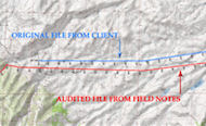
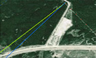
Survey Auditing & Quality ControlSantos concentrates on the data integrity of the survey data for 2D, 3D and 4D seismic and micro seismic projects ensuring the proper geodetic parameters and transformation parameters are in place, and that the most accurate geoid model is being used to compute MSL heights. A survey data audit is a last line of defense for data integrity and ensures field data is accurate and complete, improving processing flows. |
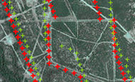
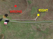
Well Location Auditing & QCSantos performs a detailed audit of the client database or published well locations versus the re-surveyed well locations if available, verifying them with imagery and original well site plats, and identifying and correcting errors in the database or published well locations. If Santos is performing the survey audit of a current seismic survey, we ensure that all wells and local survey ties are performed to provide reliable data for well audit purposes. |
Survey & GIS MappingSantos provides over 200 years combined experience in the industry to provide to our clients mapping and consulting services customized to their needs including: Well location plats, geodetic datum conversions, projection conversions, digitizing, township grid conversions, shotpoint map generation, survey location data archiving, survey extractions from stack and data archives and more. |
Geophysical Data ManagementSantos works with the client's choice of data software and our own database built on the MS Access platform to provide an economic solution to oil and gas companies to manage their seismic and survey data. We create workstation projects, well-file updates, and project conversions. We retrieve and transmit data from storage, seismic processors, and survey auditors to keep your projects running smoothly. |
Our Clients |
Case Studies |
||||||
Our Clients


|
|