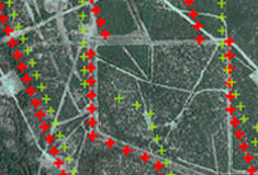
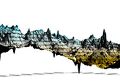
face book logo linked in logo

CLIENT LOGIN   |   SOCIAL

Santos Inc. Logo

Elevation Errors

Elevation errors due to bad rod heights and poor GPS measurements.


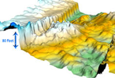
Corrected Elevations are shown.

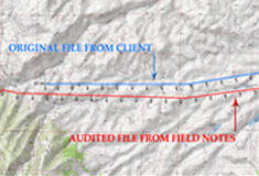
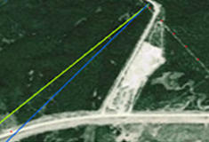
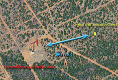
Forcing a processing contractor to correct location data and elevations brings into question the integrity of the data and ties them down with unnecessary steps to make their best attempt at correcting the data. In areas of rugged topography, this process is more difficult and may force processors to make assumptions that may turn out to be incorrect. At the end of the day your location data acts as the foundation from which all other processes flow. Survey audit ensures that data is correct, improves the processing flow, and ensures the best possible result is available for seismic interpretation.

Case Studies

seismic line superimposed on topo map

2D Survey Error

2D Survey Error in Northwest Colorado reveals discrepancies between client file and field notes

3d seismic survey info superimposed on aerial photograph

3D Survey Error

3D Survey Error causing the company to drill three times unsuccessfully into the wrong side of the fault line.

3d seismic info superimposed on aerial potograph

3D Survey Error

3D Survey Error due to the wrong datum and projection

well location data superimposed on aerial photo

Well Location Differences

Well Location Differences of two published locations of a well, in comparison to the correct re-surveyed well location.

well location data superimposed on aerial photo

Well Location Differences

Well Location mistie of 1044 feet from the published location of the re-surveyed well location.

well location info superimposed on aerial potograph

Well Location Differences

Well Location discrepancies showing 41% of re-surveyed wells in a given area have horizontal errors and 31% have vertical errors to the client's database well locations.

elevation error map

Elevation Errors

Elevation errors due to bad rod heights and poor GPS measurements.

elevation error map

Elevation Errors

Elevation errors due to incorrectly applied Geoid heights.


SANTOS INC. (c) 2013|CANADA: 403-537-5880|UNITED STATES: 214-389-7056